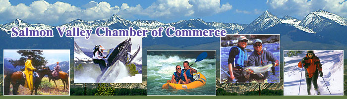
REGIONAL ATTRACTIONS
RIVERS
Salmon, Idaho boasts two world renowned wild and scenic rivers: the Main Salmon and the Middle Fork of the Salmon River. Alone, these two rivers attract well over 20,000 visitors from all over the world each year. Other major tributaries in the area include the East Fork and the North Fork of the Salmon, the Lemhi River, and the Pahsimeroi River, home to the Pahsimeroi Fish Hatchery.
Known as “The River of No Return,” the Salmon River is the longest free flowing river within one state in the lower 48. Experience one of the few remaining undammed waterways in America on a guided rafting adventure or a private river trip of your own.
Enjoy viewing an abundance of animal life
including deer, elk, black bear, bighorn sheep, mountain goat,
cougar, moose, bobcat, coyote,
red fox, and others which all can be seen throughout the rugged mountains and grassy plains through which the rivers passes.
The Main Salmon River carves the second deepest canyon in North America, (deeper than the famous Grand Canyon) second only to Idaho’s Hell’s Canyon. Approximately 180 miles of the Salmon
River Canyon are more than one mile deep. Carved through mostly metamorphic rock, nowhere in this spectacular high desert canyon is it as dramatic as where it has penetrated the igneous granite of the Idaho Batholith.
Mountain lakes abound in the Salmon area. The most accessible is Williams Lake, only 10 miles from Salmon, complete with campground and boat ramp. Iron Lake is accessible by road (Four
wheel drive is recommended) and is well worth a day trip or longer. The Bighorn
Crags are riddled with high
Alpine lakes full of fish mostly accessible by foot or horseback, as are many others in the area.
It is no wonder that the many
rivers, tributaries and lakes
the Salmon area has to offer
that it has been a desirable
fishing destination for both the
avid and recreational fisherman.
(top)
CANYONS
The Main Salmon River carves the second deepest canyon in North America, deeper than the famous Grand Canyon, second only to Idaho’s Hell’s Canyon. For approximately 180 miles, the Salmon
River Canyon is more than one mile deep. The river has carved through mostly metamorphic rock, leaving behind a spectacular high desert canyon, but nowhere is it as dramatic as where it has penetrated the igneous granite of the Idaho Batholith. With so many powerful rivers and streams in the area, it is not surprising that there are numerous canyons, large and small, to explore.
(top)
MOUNTAINS
Situated at the base of the Continental Divide, in the Northern Rocky Mountains, Salmon, Idaho is within easy reach of several major peaks, many over 10,000 feet, and an ideal base for a backcountry adventure.
Ajax, Copperhead, Freeman, Monument, and Sacajawea Peaks of the Beaverhead Mountains in the Bitterroot Range of the Continental Divide form the eastern border between Idaho and Montana. The Lemhi Mountains rise between the Lemhi and Salmon Rivers, and the Salmon River Mountains flank the Salmon River to the West. Most prominent in the Salmon River Range are the Bighorn Crags, located in the Frank Church River of No Return Wilderness.
Lemhi Pass, southeast of Salmon, at the top of Agency Creek is part of the Lewis & Clark Back Country Byway. At 7,323 feet this historical pass is the site where, in 1805, the Lewis and Clark Corps of Discovery expedition first saw the headwaters of the Columbia River. Open from June to early fall to motorists it is a favorite for the snowmobilers in the winter on the groomed trails.
Lost Trail Pass located on Highway
93, 45 miles north of Salmon, is open year round and provides panoramic views of the area at 7,014 feet, and the best access to all forms of winter recreation. The Lost Trail Ski area offers
several ski lifts to over to a
multitude superb ski trails
Gilmore Summit located 35 miles south of Salmon on Highway 28 is the easiest of the passes into the Salmon Valley. Take a side trip and have a picnic at Meadow Lake or visit the old ghost town of Gilmore.
Bannock Pass is
located south of Salmon and crosses
the Continental Divide to connect
with I-15 near Dillon, Montana.
Pack a picnic and stop at Clark
Canyon Reservoir and Dam and enjoy
fishing or playing in the water.
(top)
LAKES
Mountain lakes abound in the Salmon area. The most accessible is Williams Lake, only 10 miles from Salmon, complete with campground and boat ramp. Iron Lake is accessible by road (four
wheel drive is recommended) and is well worth a day trip or longer. The Bighorn crags are riddled with high Alpine lakes,
filled with fish mostly accessible by foot or horseback, as are many others in the area.
(top)
BACKCOUNTRY TRAILS
The Lewis & Clark Trail crosses Lemhi County and opportunities abound to re-live the Lewis & Clark adventure. It was here that the expedition crossed the Continental Divide searching for a water route to the Pacific only to be turned back by the turbulent waters of the Salmon River.
The Nez Perce National Historic Trail enters Lemhi County near the town of Leadore.
In addition to these historic trails, the mountains and foothills surrounding Salmon are laced with hiking, biking, skiing, snowmobiling, ATV and horseback riding trails.
(top)
WILDERNESS
The Frank Church River of No Return Wilderness the largest
wilderness area in the lower 48 states, encompassing the Middle Fork of the Salmon River, and bordering much of the Main Salmon River.
The Frank Church Wilderness is connected to the Selway-Bitterroot Wilderness to the north, and the Gospel Hump Wilderness to the northwest. The proximity to this vast primitive area, positions Salmon, Idaho as one of the best jumping off points for backcountry forays into the central Idaho
wilderness.
(top)
WILDLIFE
If it is wildlife viewing that you seek, then there is no better place to visit than the Salmon, Idaho. Just driving through will offer you the chance to see
bald eagles, osprey, red tail hawks,
antelope, elk, big horn sheep and of course both
rule and white tail deer. At times motorists are treated to
moose, black bear and mountain goat as well. There is no fee to drive our wildlife corridor, and the animals you’ll see are wild and unprotected, unlike those you find in many
national wildlife parks. But don’t settle for what you may see from the road, the best wildlife encounters are waiting for you just down the trail, or around the bend!
(top)
HOT SPRINGS
Gold Bug Hot Springs –
undeveloped,
approximately 20 miles south on Highway 93, just south of Elk Bend. Includes 2.5 mile moderately strenuous hike to the hot springs.
Sharkey Hot Springs – developed, along the Backcountry Byway off Highway 28.
Follow Highway 28 south for
approximately 17 miles, turn right
onto 17 Mile Lane/Haynes Creek Road,
at the Y follow the road to the
right approximately 2 miles.
Turn right onto the Warm Springs
Wood Road and follow the road until
you reach the hot springs.
Panther Creek Hot Springs – undeveloped, currently out of use due to mud slides.
Horse Creek Hot Springs – semi-developed, off the Salmon River Road, need USFS map.
(top)
GHOST TOWNS
Gilmore
Follow Highway 28 South of Salmon (approximately 60 miles), and you will reach Gilmore Summit and the old mining town of Gilmore. Deserted during the depression of 1929, about 40 buildings still remain. The Gilmore & Pittsburg Railroad, better known as the G & P or “Get Off and Push” Railroad, ran between Armstead, Montana, Salmon and Gilmore, Idaho.
Leesburg
Along with four friends, Frank Barney Sharkey discovered gold in 1866 below the North Fork of the Salmon River. The mining town of Leesburg grew to a population of seven thousand in a few short years. It is estimated that as much as $40 million in gold has been removed from the mines of Leesburg, a town named after General Lee by it’s residents, mostly soldiers of the Civil War. By the end of World War II the town was mostly deserted - only a few cabins stand today.
Nicholia Charcoal Kilns
Nicholia was established in 1885 when a two stack smelter was built. By 1889, Nicholia had a population of over fifteen hundred people. The Viola Mine was located high on a ridge behind the town and tramways brought the ore to the smelter. Evidence of the old tramway can still be seen. The charcoal kilns built to supply the smelter with fuel are located across the valley. Four of the original sixteen kilns remain standing today. Self Guided Tour.
Shoup
Along the River Road, West of North Fork, on the banks of the Salmon River, is the Historic township of Shoup, established in 1881. Once a thriving gold mining town, Shoup, re-named after Idaho's Governor Shoup, still survives as a remote outpost (population 4) servicing the many adventurers who come to enjoy the river canyon each year. Although most of the mining cabins are in ruin, many historic cabins remain in tact and in use, not least the old log schoolhouse, which now provides lodging for fishermen, hunters and rafters. Many historic mills and mining equipment also remain along the canyon, and until 2004, gold mine tours were available daily at the largest gold mine in the area. Now, tours are available only through guided river trip operators. Explore this living relic and learn how the “ River of No Return” got its name.
-Other Ghost Towns -
Blackbird
Cobalt
Grantsville
Hahn
Junction
Kingville
Lava
Leadville
Reno
Smithville
Summit City
Yellowjacket
(top)
SCENIC BYWAYS
No matter which way you enter Salmon, you are following a national scenic byway.
Salmon River Scenic Byway - Highway 93 runs
from Challis to Lost Trail Pass.
Sacajawea Historic Byway - Follow the trail of Sacajawea and the Lewis and Clark Corps of Discovery. Begin at the junction of Interstate 15 and
state Highway 33 to Highway 28 and on to Salmon.
Sacajawea, an "Agaidika" Shoshone woman born around 1788, was a valuable member of the Lewis and Clark Corps of Discovery. Born and raised in Idaho’s Lemhi Valley until the age of twelve, she was captured by the Arikira Indians and forced to live in the Mandan Villages of North Dakota. Carrying her infant son and acting as an interpreter for Lewis and Clark, Sacajawea, would help the Corps find the Salmon River and in doing so would revisit her people.
Found here are fossils of the extinct Pleistocene lion, Native American rock art, and stories of the Lemhi-Shoshone people. Follow the stage routes and rail lines that served the mining boom of the late 1800's. Learn more of the flight of the Nez Perce, Fort Lemhi, and Chief Tendoy.
Lewis & Clark Back Country Byway - Begins 20 miles
south of Salmon then east from Highway 28 at the Tendoy Store. View country that looks much the same as when Lewis and Clark first discovered it. Things to see
include: Back Country Interpretive Kiosk; Sharkey Hot Springs; Lemhi Pass (first crossing by Lewis and Clark of the Continental Divide); 1st Flag Unfurling Site; Continental Divide National Scenic Trail; Headwaters of the Missouri River. Trail is open summer and early fall. Groomed trails open to snowmobile enthusiast.
Camping: BLM Agency Creek recreation site at Milepost 33. Tent and trailer campsites, toilets, no potable water available.
The “ Salmon River Road” - West from North Fork to Corn Creek (the end of the road) offers a great drive along Salmon River through the
historic township of Shoup. Almost fifty miles of outstanding wildlife viewing, rugged scenery, historic mines, Native American pictographs, and depending on the time of year, great entertainment watching rafters navigate the whitewater stretches or fishermen pulling steelhead trout from the water.
(top)
SACAJEWEA CENTER
Created to honor Sacajawea, who was born in the Salmon Valley, the Sacajawea Center provides visitors and locals alike a place to walk, visit, watch performances and learn about the area and the inhabitants.
LEWIS & CLARK
Tower Rock Recreation
Site - A BLM Campground, is located 11 miles north of Salmon on
Highway 93. A detachment led by William Clark camped here on August 21 and 25, 1805 while completing the reconnaissance of the Salmon River. Interpretive panels highlight the geology of Tower Rock and Clark's Campsite.
Tower Creek Pirimids(sic) – The Lewis and Clark expedition traveled up Tower Creek on August 31st 1805. Clark recorded, "...passed remarkable rock resembling pirimids on the left side." The day use site offers picnic tables and an historic homesteader's cabin. Information panels interpret the geology of the "pirimids".
For more information on any of the above, contact the following:
Salmon Valley
Chamber of Commerce:
1-208-756-2100, or 1-800-727-2540.
Salmon/Challis National
Forest: (208) 756-5100.
(top) |